A research-based design practice where on-the-ground ecosystem design builds ecological function, conservation knowledge, and community voice — generating the science, the advocates, and the policy momentum that 21st century conservation demands.
Site-level ecosystem design rooted in landscape ecology, succession science, and regional conservation priorities.
Every project is designed to function as part of something larger — linking properties to regional corridors and conservation systems.
Field documentation and applied research that connects on-the-ground practice to conservation knowledge and policy.
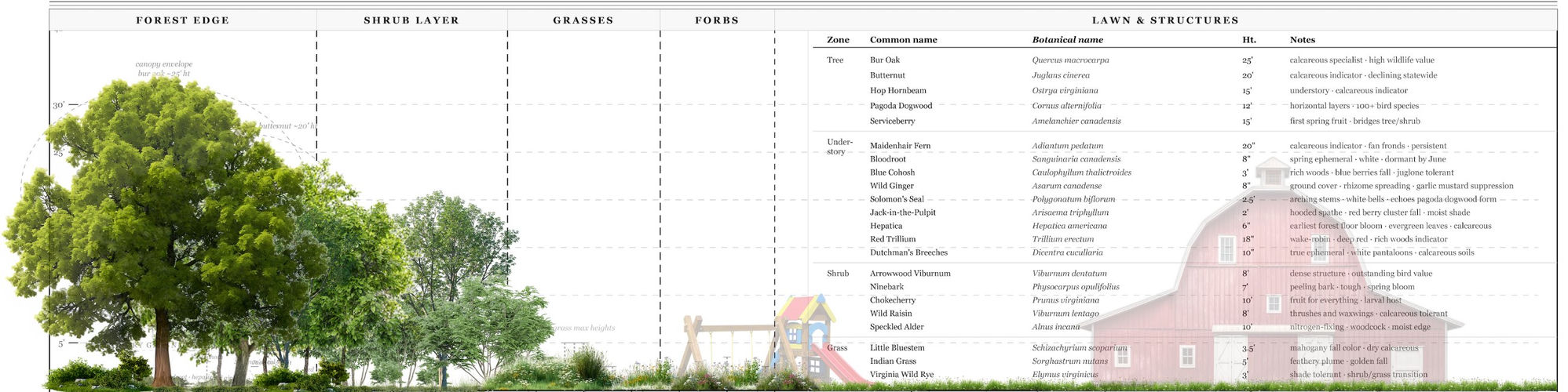
In functional ecological systems, the richest biodiversity occurs not at the center of habitat types, but at the transitions between them — the riparian edge, the woodland margin, the shrub corridor dissolving into meadow. These are gradients, not boundaries. The practice is named for this principle, and it shapes every design decision we make.
Where conventional landscape design draws a hard line between maintained lawn and planted area, Gradients designs the full sequence — from forest canopy through shrub layer, into grasses and forbs, to the structures and spaces where people live and work. Every zone is functional. Every transition is intentional.
A single property, no matter how well-designed, cannot sustain species persistence in isolation. What determines whether individual habitat patches become functional ecological systems is connectivity — how they relate to corridors, riparian networks, adjacent conservation lands, and the regional landscape as a whole.
This is not a metaphor. It is the literal problem we design for. Every project begins with the question: what does this property need to do to be part of something larger than itself?
21st century conservation cannot be practiced as if people and nature occupy separate spheres. The landscapes we design are lived in, worked on, and loved. The communities whose landowners we work with hold conservation potential that policy alone cannot unlock.
The design process is where that potential becomes legible — where a landowner becomes a steward, and a steward becomes an advocate, and an advocate becomes part of the science and policy that shapes what conservation looks like for the next generation.
Every species in the palette is chosen against a specific set of conditions — soil pH, drainage, light, disturbance history, regional context. Vermont Valley calcareous soils are demanding and distinctive: they select hard, reward precision, and support species assemblages found nowhere else in the Northeast.
Butternut, Bur Oak, Maidenhair Fern, Red Trillium — these are not ornamental choices. They are indicators. Their presence in a well-functioning design is a measurement of how well the underlying ecological logic holds. The palette is the hypothesis. The landscape is the test.
The zone-by-zone structure of every Gradients design is deliberate. Forest Edge into Shrub Layer into Grasses into Forbs into the managed edge — each transition is its own habitat type, each supporting different species assemblages, different seasonal functions, different relationships to adjacent zones.
What looks like a designed landscape is actually a managed gradient. The goal is not a fixed aesthetic but a trajectory: a landscape that becomes more complex, more functional, and more ecologically integrated over time — one that earns its place in the larger regional system it is part of.
Every property exists within a landscape, and every landowner exists within a community. We begin with both — understanding the regional conservation priorities and the human context — and work inward to the site. The design process itself is where knowledge is built and voice is developed.
Applying current ecosystem design principles on the ground, studying what works, and contributing to the ecological knowledge that connects practice to policy. Field research, biodiversity documentation, white papers, and stewardship plans that make on-the-ground conservation legible to land trusts, state agencies, and policymakers — giving landowners a durable framework and a voice in the larger conservation conversation.
State conservation priority frameworks, wildlife action plans, and biodiversity targets provide the scientific and policy framework within which every project is situated.
Conservation landscapes mature into their function over time. We design with succession in mind and build stewardship plans that allow properties to evolve with their ecology — not against it.
Site-specific design that serves both human and ecological needs. Native plant palettes calibrated to site conditions — riparian and wet-soil edges, woodland and woodland-edge transitions, meadow and pollinator habitat. Designed to contribute to landscape-scale connectivity while creating spaces people can love, understand, and be part of.
We evaluate each property's ecological position within the regional landscape — connectivity potential, species-relevant habitat quality, riparian function, and relationship to conservation priority classifications, wildlife action plan priorities, and adjacent conservation lands.
Native species matched to site conditions produce landscapes that are richer, more dynamic, biologically diverse, and more beautiful over time. The goal is a landscape that reveals its function — where the design reflects the ecology of the place.
Conservation at landscape scale requires more than good design — it requires people who understand what's at stake and have a voice in shaping what comes next. Working with landowners, practitioners, and community members to build ecological literacy, shared identity, and the collective voice that moves conservation priorities from aspiration to policy.
Working with landowners on their property isn't just design delivery — it builds their ecological knowledge, investment, and conservation voice. That voice matters for advocacy and policy in ways that expert opinion alone cannot achieve.
Meet the land and the people who steward it. Walk the property, listen to the landowner, and understand the ecological and human context before any assessment begins — what's here, what's possible, and what the land means to the people who live with it.
Evaluate the property's ecological position: connectivity potential, habitat condition, species-relevant site factors, relationship to SWAP priorities, conservation frameworks, and adjacent conservation lands. Understand what the landscape needs before designing for it.
Develop a site-specific conservation landscape design — native plant palette, habitat zones, connectivity features, stewardship plan — calibrated to ecological goals, site conditions, and how the land will be used and experienced by the people who call it home.
Implement the design, study what it's doing ecologically, and document outcomes — producing conservation records legible to land trusts, state agencies, and policy audiences, and giving the landowner a durable voice in the larger conservation conversation.
Private landowners, conservation organizations, and land stewards who want their properties to function as part of the larger landscape — and who want to be part of the larger conservation conversation.
Who We Serve
Who We Work With
When They Call Us
The best starting point is a conversation about your property, your goals, and the landscape it's part of.
Start a ConversationHeather Davis Miller · Founder & Executive Director
heather@justconservationsolutions.com